Posted on September 5, 2017 by Mariangela
Expanding EO4SD scope to EU eastern neighbourhood
In 2016 the ESA’s EO for Sustainable Development (EO4SD) initiative expanded to include dedicated activities in Europe’s eastern neighbourhood. This move brought new perspectives to development cooperation opportunities especially for the ESA’s new member states in terms of geographic focus on the Eastern European Region (EER).
The project called EO4EP – Earth Observation for Eastern Partnership – spans Poland, Czech Republic, Georgia, Moldova and Armenia, focusing on EO services development and capacity building for flood management and agriculture. It aims to achieve a step increase in the uptake of satellite-based environmental information in the development programs implemented by the World Bank and the European Investment Bank in the EER, as well as to promote regional cooperation and knowledge exchange.
The Eastern Partnership countries are active recipients of the Official Development Assistance (ODA) transfers from the European countries as well as from international financing institutions (IFIs) to advance their socio-economic growth. During 2016 and 2017 the EO4EP project, represented by Polish and Czech EO service providers (Geosystems, Astri Polska, Geopulse, CBK PAN, Gisat) and development organizations (PCPM), conducted several missions to Armenia, Georgia and Moldova in order to identify key IFI investment projects in agriculture and land management that can benefit from the use of geospatial information services in investment design and implementation.
Agriculture productivity assessment and irrigation planning and management are some of the areas where Earth Observation plays an important role providing data on distribution of cropland areas and water use. Collaborations have been established with ministries of agriculture and natural resources management in Armenia and Georgia to develop and demonstrate tailored services capable of providing monitoring of the agricultural productivity, irrigation performance, as well as crop statistics based on the exploitation of MODIS, Sentinel and Landsat data. The Armenian State Committee for Water Management, which is leading the implementation of the WBG-financed Irrigation System Enhancement Project, plans to benefit from EO services to improve the irrigation efficiency in the targeted irrigation schemes (Meghri, Gegardalich, Baghramyan – Norakert and Kaghtsrashen systems). This involves enhancement of GIS software for the management of irrigation plans to better monitor irrigation water intake, water delivery, electricity consumption and to generate information on cultivated lands, water sources and crop types. The Georgian Ministry of Agriculture and Georgian Amelioration – a Georgian state-owned company carrying out irrigation improvement and management services – are going to benefit from similar data delivery systems and capacity building activities developed specifically to support World Bank Georgia Irrigation and Land Market Development projects.
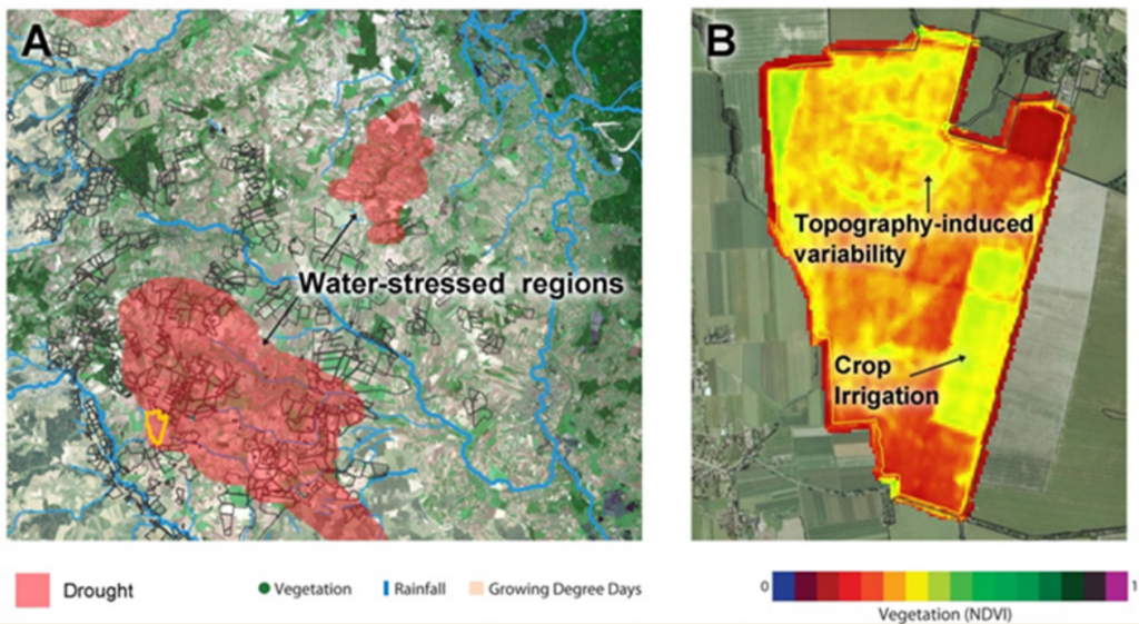
Example of the agriculture productivity monitoring service. Credit: Geopulse for ESA/World Bank, 2017.
Another major user of EO4EP services is the national Institute of Meteorology and Water Management (IMGW), a Polish state-owned research and development unit offering various services and expertise in the field of meteorology and hydrology. IMGW serves as one of the implementing agencies for the World Bank-led Odra-Vistula Flood Management Project, whose objective is to increase access to flood protection for people living in selected areas of the Odra River and the Upper Vistula River basins, and to strengthen the institutional capacity to mitigate the impact of floods more effectively. The EO4EP project will focus on development of river ice monitoring system for the IMGW and its regional agencies, and land cover mapping in the selected river basin to better predict seasonal water retention capacity. These experiences will also be a part of the peer-to-peer capacity building program with Moldova where several flood protection climate change adaptation investments are taking place under the leadership of World Bank and European Investment Bank.
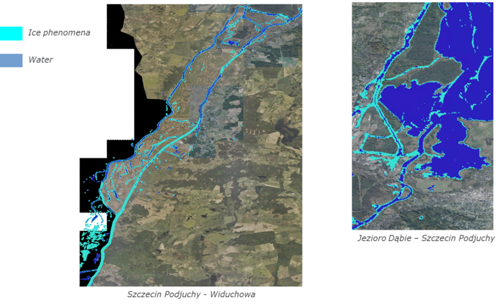
Example of the River Ice monitoring service. Detected ice phenomena on 14th February 2017 (Sentinel-1 data; ortophotomap: geoportal.gov.pl). Credit: Astri Polska for ESA/World Bank, 2017
This emerging regional collaboration in Earth Observation will be further strengthened over 2017 and 2018 with a series of events that will bring the partners together for capacity building and knowledge exchange workshops.