Posted on December 18, 2017 by Mariangela
Predicting slum dwellers’ deprivations from space: a pilot study on Dhaka (Bangladesh)
One of the most pressing development challenges in today’s world of rapid urbanization is how to respond to the unmet demand for basic infrastructure services, like adequate housing, clean water and sanitation. Half of the world’s population lives in cities and close to 1 billion live in slums. Megacities in developing countries are growing faster than ever, mostly in an unplanned way. Dhaka, the capital of Bangladesh, is particularly challenged due to congestion, poor infrastructure and regular flooding during heavy rainfall. In fact, according to the Economist Intelligence Unit, it was ranked number 137 out of 140 in the list of world’s livable cities.
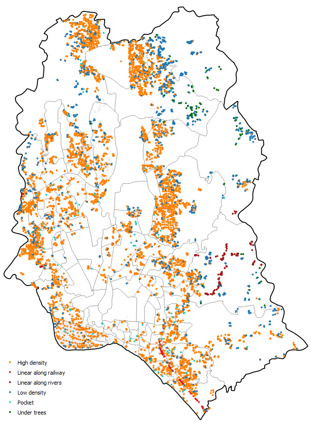
Dhaka Metropolitan Area – Informal settlements classified by density, shape & context indicators
When looking at approaches to upgrade slums, a challenge is often a lack of adequate data, particularly spatial data. Standard mapping rarely keeps up to cover such rapid growing of unplanned settlements, whereas conducting household surveys is useful, but they are expensive and hence not frequently updated. This represents a critical issue when trying to monitor dynamic and elusive slums, whose very definition is controversial and context-specific.
In such framework, effective support might come from Earth observation (EO) data which are already being used in several other applications (e.g., recognizing cross-border territories in disputes, tracking wildlife, locating hazards and disasters, identifying migration patterns).
Specifically, along with very high resolution imagery, advanced algorithms are being developed which can be used to detect and describe slums, answering critical questions as:
- Where are slums/informal settlements located?
- How do their appearances change over time?
- Do they present spatial characteristics incompatible with basic infrastructure supply (living space, water and sanitation, roads and safety from natural hazards)?
With an eye towards using innovative data analytics for development impact in slums, World Bank’ Water Practice (GWAGP) launched a pilot in Dhaka under the ‘Water Supply and Sanitation in Rapid Urbanization’ umbrella about a year ago. GWAGP worked in collaboration with the WASH Poverty Diagnostic team in Bangladesh, the EO4SD-Urban consortium (where GISAT had a prominent role) and researchers from the University of Massachusetts Boston. Preliminary results from Phase 1 of the study have been presented to the bank stakeholders, explaining how the information of in-depth household surveys can be complemented with geoinformation captured from satellites for Dhaka slums.
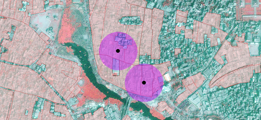
Informal settlements in Dhaka (close-up): Slum areas (pink polygons) and buffers around slum WASH-P communities’ location (purple circles). Source: GISAT, 2017
The Details
In the developed approach, several EO-derived indicators feed into a statistical model to predict an index of household deprivation called Slum Severity Index (SSI). The SSI captures the needs of slum residents for access to safe water, access to adequate sanitation, durable housing construction, sufficient living space, security of tenure, and metered electricity.
Here are some examples of insights obtained from the preliminary analysis of combined EO and survey response data in Dhaka:
- As the distance from central business district and from major roads increases, the lack of water or electricity increases (known as “peripheralization of slums” phenomenon);
- Where the percentage of high density residential urban fabric increases, housing deprivation also increases;
- The indicators for building density (e.g., average dwelling size and distance between buildings) are associated with worsening housing and basic services.
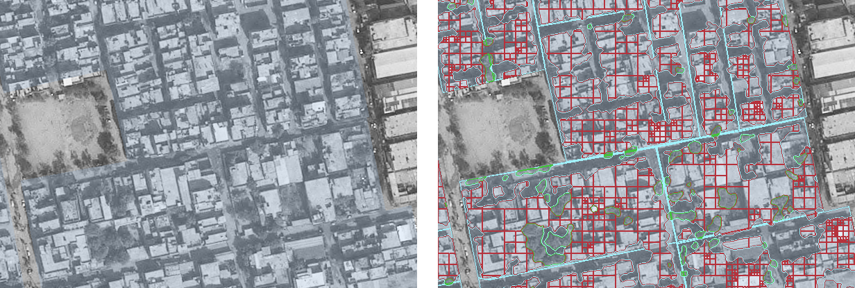
Informal settlements in Dhaka (close-up) – Area homogeneity indicator
Quad-tree segmentation within built-up mask as an estimation of area homogeneity indicator. Source: GISAT, 2017
Mapping these deprivation indicators and identifying the degree to which they intersect could help make the prioritization of ways to upgrade slums easier. Citywide programs are not always feasible, so gaining spatial awareness of unmet needs can benefit local governments and utilities to identify the most under-served neighborhoods or to tackle critical bottlenecks, such as tenure insecurity. In addition, this approach can bring valuable information at a fraction of the cost, even with small sample surveys, that could be used to inform the design of complex operations.
This initiative is still in progress for Phase 2. Meanwhile, results are currently disseminated and the methodology is being tweaked for making it more robust and easily transferable to other cities. The sky is the limit on how far this can be further developed to help identifying needs and combat poverty.
For questions, comments or suggestions on potential applications of the approach, please contact Luisa M. Mimmi (WB GWAGP), Christian Borja-Vega (WB GWA04), Tomas Soukup (GISAT), Jan Kolomaznik (GISAT) or Amit Patel (University of Massachusetts Boston).
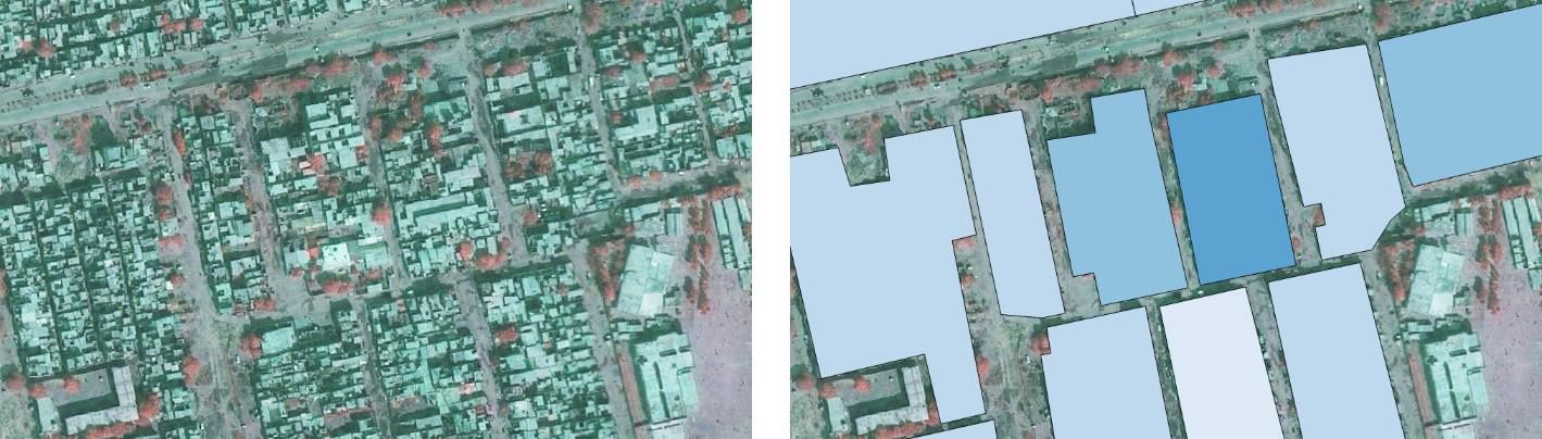
Informal settlements in Dhaka (close-up) – Mean dwelling size indicator
Mean dwelling size derived indicator example comparing units with different size setting. Source: GISAT, 2017
Comments
1 Comment
what is the outcome of this research?
what benefit was received by the slum dwellers ??